
File:Map of Rome and Carthage at the start of the Second Punic War.svg

Size of this PNG preview of this SVG file: 800 × 576 pixels. Other resolutions: 320 × 230 pixels | 640 × 461 pixels | 1,024 × 737 pixels | 1,280 × 921 pixels | 2,560 × 1,843 pixels | 1,067 × 768 pixels.
Original file (SVG file, nominally 1,067 × 768 pixels, file size: 406 KB)
Captions
Captions
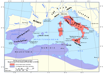
A map of the Mediterranean showing the territories controlled by Rome and Carthage in 218 BCE.
Summary
[edit]| Description |
English: Map showing Rome and Carthage at the start of the Second Punic War and the theatre of the Punic Wars. |
|||||||||||||||||||||||
| Date | (UTC) | |||||||||||||||||||||||
| Source |
This file was derived from: Rome carthage 218.jpg:
|
|||||||||||||||||||||||
| Author |
|
|||||||||||||||||||||||
| Other versions |
[]
|
|||||||||||||||||||||||
.png)


Licensing
[edit]
This file is licensed under the Creative Commons Attribution-Share Alike 3.0 Unported license.
- You are free:
- to share – to copy, distribute and transmit the work
- to remix – to adapt the work
- Under the following conditions:
- attribution – You must give appropriate credit, provide a link to the license, and indicate if changes were made. You may do so in any reasonable manner, but not in any way that suggests the licensor endorses you or your use.
- share alike – If you remix, transform, or build upon the material, you must distribute your contributions under the same or compatible license as the original.
Original upload log
[edit]
This image is a derivative work of the following images:
- File:Rome_carthage_218.jpg licensed with PD-US
- 2006-11-17T15:51:02Z Rune X2 1108x822 (194898 Bytes) == Summary == '''Rome and Carthage at the Beginning of the Second Punic War, 218 B.C.''' Scan from "Historical Atlas" by William R. Shepherd, New York, Henry Holt and Company, 1923. Original image at the [http://www.lib.ut
Uploaded with derivativeFX
File history
Click on a date/time to view the file as it appeared at that time.
| Date/Time | Thumbnail | Dimensions | User | Comment | |
|---|---|---|---|---|---|
| current | 07:44, 30 September 2024 | | 1,067 × 768 (406 KB) | Theklan (talk | contribs) | File uploaded using svgtranslate tool (https://svgtranslate.toolforge.org/). Added translation for eu. |
| 07:43, 30 September 2024 |  | 1,067 × 768 (406 KB) | Theklan (talk | contribs) | File uploaded using svgtranslate tool (https://svgtranslate.toolforge.org/). Added translation for eu. | |
| 11:17, 12 June 2012 |  | 1,067 × 768 (362 KB) | Grandiose (talk | contribs) | Tweak caps of "Miles" & "Kilometers" and rm long/lat on 'wrong' sides | |
| 12:48, 28 May 2012 |  | 1,067 × 768 (364 KB) | Grandiose (talk | contribs) | uploaded wrong version before | |
| 12:35, 28 May 2012 |  | 1,067 × 768 (364 KB) | Grandiose (talk | contribs) | Various tweaks per FPC | |
| 12:52, 22 May 2012 |  | 1,067 × 768 (360 KB) | Grandiose (talk | contribs) | Remove clipping which is buggy; tweak border stroke | |
| 08:31, 11 May 2012 |  | 1,067 × 768 (453 KB) | Grandiose (talk | contribs) | Typeface change | |
| 18:58, 10 May 2012 |  | 1,067 × 768 (449 KB) | Grandiose (talk | contribs) | Tweaks | |
| 14:14, 10 May 2012 |  | 1,067 × 768 (449 KB) | Grandiose (talk | contribs) | Fix Danube I think, take in the margins slightly. | |
| 13:36, 9 May 2012 |  | 1,077 × 776 (445 KB) | Grandiose (talk | contribs) | Got myself confused there. |
You cannot overwrite this file.
File usage on Commons
The following 27 pages use this file:
- Atlas of Algeria
- Atlas of Egypt
- Atlas of European history
- Atlas of Galicia
- Atlas of Libya
- Atlas of Morocco
- Atlas of Portugal
- Atlas of Spain
- Atlas of Tunisia
- User:Magog the Ogre/Multilingual legend/2024 September 26-30
- File:Map of Rome and Carthage at the start of the Second Punic War-ar.png
- File:Map of Rome and Carthage at the start of the Second Punic War-de.svg
- File:Map of Rome and Carthage at the start of the Second Punic War-es.svg
- File:Map of Rome and Carthage at the start of the Second Punic War-nl.png
- File:Map of Rome and Carthage at the start of the Second Punic War-pt.svg
- File:Map of Rome and Carthage at the start of the Second Punic War-ru.svg
- File:Map of Rome and Carthage at the start of the Second Punic War-zh.svg
- File:Map of Rome and Carthage at the start of the Second Punic War.svg
- File:Map of Rome and Carthage at the start of the Second Punic War 2.svg
- File:Map of Rome and Carthage at the start of the Second Punic War Modified-fr.svg
- File:Map of Rome and Carthage at the start of the Second Punic War Modified.svg
- File:Map of Rome and Carthage at the start of the Second Punic War ko.svg
- File:Map the Second Punic War-hu.svg
- File:Rome carthage 218.jpg
- File:The flight of C. Marius.png
- Template:Other versions/Map of Rome and Carthage at the start of the Second Punic War
- Category:Punic Wars
File usage on other wikis
The following other wikis use this file:
- Usage on ang.wikipedia.org
- Usage on azb.wikipedia.org
- Usage on ban.wikipedia.org
- Usage on bg.wikipedia.org
- Usage on bn.wikipedia.org
- Usage on br.wikipedia.org
- Usage on bs.wikipedia.org
- Usage on ca.wikipedia.org
- Usage on cs.wikipedia.org
- Usage on cy.wikipedia.org
- Usage on el.wikipedia.org
- Usage on en.wikipedia.org
- Second Punic War
- Campaign history of the Roman military
- Portal:Spain
- Lex Claudia de nave senatoris
- Western world
- Template:Infobox military conflict/testcases
- Wikipedia:Featured picture candidates/May-2012
- Wikipedia:Featured picture candidates/Second Punic War
- Wikipedia:Featured picture candidates/Second Punic War (2)
- Wikipedia:Featured picture candidates/June-2012
- Wikipedia:Featured picture candidates/Second Punic War (3)
- List of conflicts in Morocco
- User:InformationvsInjustice/sandbox2
- Wikipedia:Today's featured article/October 2022
- Wikipedia:Today's featured article/October 15, 2022
- Wikipedia:Main Page history/2022 October 15
- Wikipedia:Main Page history/2022 October 15b
- Usage on et.wikipedia.org
- Usage on eu.wikipedia.org
- Usage on fa.wikipedia.org
- Usage on ga.wikipedia.org
- Usage on gl.wikipedia.org
- Usage on he.wikipedia.org
- Usage on hy.wikipedia.org
- Usage on id.wikibooks.org
View more global usage of this file.